
Friday, July 20, 2012
Boonsborough Museum of History
Wednesday, July 18, 2012
The Confederate Invasion of Iowa

Site of the Confederate Invasion of Iowa, 12th Day of October, 1864. This monument marks the northern most point of incursion into Iowa by Confederate Forces. On October 12, 1864, Lieutenant James “Bill” Jackson led twelve heavily armed Missouri Partisan Rangers dressed in Union uniforms in a raid through Davis County, Iowa, resulting in the murder of three local citizens. • This Plaque Dedicated in 2005 • Davis County Civil War Guerrilla Raid Society.

The incomparable Historical Marker Database records the Bloomfield marker at 40° 44.5′ N. The good folks near Salineville, Ohio have a marker, too. And though it's only as far north as 40° 37.228′ N, they claim the northernmost distinction as well. The Ohio marker reads:
Here, on July 26, 1863 occurred the northernmost engagement of Confederate forces during the Civil War. In this immediate area, troops under Major General John H. Morgan, C.S.A., and General James Shackelford, U.S.A., met in full engagement. After evading Union troops, Morgan’s forces were re-formed at Norristown, from whence they proceeded to West Point, where Morgan surrendered his command.I think you have to give the nod to Salineville, since Morgan's Raiders were full-fledged CSA units detached from a Confederate army before making their monumental raid. The Iowa incursion, by contrast, sounds more like a gang, even resorting to the use of disguise. We won't even entertain notions about the St. Albans, Vermont raid (bank robbers!), or naval actions.
Sunday, July 15, 2012

Saturday, July 14, 2012
Antietam from an Oktokopter
. . . found at Brooks Simpson's Crossroads blog: This video of Antietam National Battlefield was acquired on July 5th, 2012 using an Oktokopter XL and dual GoPro cameras (click on the image to go to the video).

Sunday, July 08, 2012
Friends of the Little Bighorn Battlefield

A very worthwhile organization. I attended the annual meeting last month at the battlefield, and the highlight of my trip was the Friends-sponsored walk down Deep Ravine Trail with Dr. Richard Fox. Please consider supporting them -- they're making a tangible difference at an understaffed, and underfunded national monument.
Thursday, July 05, 2012
Little Bighorn Battlefield, 136th anniversary
Some select photos from my recent Montana trip. These, and quite a few others (46 total) can be viewed here.


 |
| Looking down to the scene of the valley fight from Reno hill. |
 |
| Water Carrier's Ravine, Reno-Benteen Defense Site, where so many earned the Medal of Honor. |
 |
| Weir Point -- Last Stand Hill is at the right edge of the trees on the horizon (trees in the Nat'l Cemetery and aound the Visitor's Center) |
 |
| Look west from Weir Point toward the river, and village site. |
 |
| Mouth of Medicine Tail Coulee |
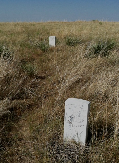 |
| Where Lieutenants Calhoun, front, and Crittenden fell. |
 |
| Keogh Sector. Keogh fell where the cluster of markers is on the far right. |
 |
| Last Stand Hill |

 |
| At sunrise on the 136th anniversary. |

 |
| Spirit Warriors Sculpture, Indian Memorial |
 |
| Dr. Richard Fox leading a walk down Deep Ravine Trail. |
 |
| Author signing: Left to right, Jeff Barnes, Paul Hedren, Neil Mangum, Richard Fox. |
 |
 |

 |
| Many red granite warrior markers now grace the field. |
 |
| Hey, it's the Georgia flag. From about 10 years ago. Hardin Reenactment. |
 |
| Real Bird reenactment at near Medicine Tail Ford, Crow Reservation. |
 |
| Real Bird reenactment. |
 |
| Real Bird reenactment. |
Review: The Long Road to Antietam

A review of The Long Road to Antietam: How the Civil War Became a Revolution, by Richard Slotkin. Found at the Lawyers, Gun$ and Money blog.
The story may be familiar, but Slotkin adds much to it. He convincingly demonstrates that the Union was in a precarious position in 1862. Not only had the war gone badly in the face of superior military leadership in the Confederacy, but the North was disunited. Slotkin puts the lie to Doris Kearns Goodwin’s idea of a Team of Rivals, noting that disagreements in the Cabinet severely hurt the prosecution of the war in its first year. Meanwhile, despite the commonly held belief that Jefferson Davis had a strained relationship with his generals, Slotkin shows that, in 1862 at least, Davis and Lee were quite close and agreed on both short and long-term strategy, providing a much more unified front than the Union.
Read the full review here.
Tuesday, July 03, 2012
Battle of the Rosebud, Prelude to the Little Bighorn
About a week ago I drove down to the Rosebud Battlefield State Park from Hardin, Montana—headquarters from my Little Bighorn sojourn—and spent a little time poking around. I had read Neil Mangum's battle study only a few weeks before, and I was glad I had the book with me, as the maps were indispensable to getting oriented. Read a short summary of the battle by Neil Mangum here.
Neil did a site study of the Rosebud field back when he was historian or superintendent at Little Bighorn. We're all very fortunate that the land owner wished to see this battlefield preserved, even as mining concerns were taking a very active interest. Now it's about the most pristine field imaginable—very remote, and quiet. There are no trails to speak of, but one overgrown access road allows you to climb Crook's Hill, from which most notable sites on the field can be discerned.
Mining still remains a threat, however, as Montana only owns the surface rights to the property.
 |
| Direction from which the Sioux and Cheyenne attacked. Behind the camera is the broad valley of the Rosebud. |
 |
| Add caption |
 |
| Van Vliet's Ridge |
 |
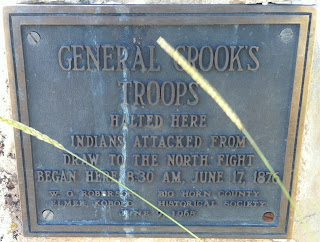
| The only monument on the battlefield, as far as I could tell. |

"Brothers in Arms," by Terry Jones
An interesting essay from yesterday's New York Times Disunion blog:
"How two units, one Union, one Confederate, that fought in 1862 Virginia found themselves fighting alongside each other in Iraq"
"How two units, one Union, one Confederate, that fought in 1862 Virginia found themselves fighting alongside each other in Iraq"


Sunday, July 01, 2012

Crazy Horse Sunrise
Little Bighorn National Monument, Indian Memorial, June 25, 2012
[I took this picture last Monday, on the 136th anniversary]
[I took this picture last Monday, on the 136th anniversary]

Subscribe to:
Posts (Atom)